Designing a bridge across a river often begins by making it experience an earthquake inside a computer. Before pressing the run button, however, another question needs an answer: how will the ground beneath each pier actually move? The shapes of the banks, riverbed and underground layers can send incoming seismic waves along different paths.
Seismic waves must travel through layers of ground
Think of the ground as a collection of materials with different personalities: some soft, some stiff, and each with its own thickness. Waves passing through them undergo reflection, transmission and amplification. The two ends of a river crossing also encounter different terrain, while the river water places additional pressure on the bed.
Using the site of a long-span continuous rigid-frame bridge, this study compares three ways to prepare seismic inputs: synthesizing motions from a response spectrum, using a one-dimensional model of vertically layered soil, and using a two-dimensional model that retains the valley shape and variations in the layers. These are three portraits of the same site, drawn at different levels of detail.
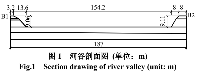
The valley cross-section helps explain the difference between one and two dimensions. A one-dimensional calculation mainly follows waves travelling up and down a soil column. A two-dimensional calculation also allows horizontal propagation and retains the riverbed depression and changes in layer thickness. Two bridge piers may sit at different distances from the valley and on different ground. During propagation, these differences become two distinct ground motions that act together on the deck through the piers.
Similar peaks can conceal different rhythms
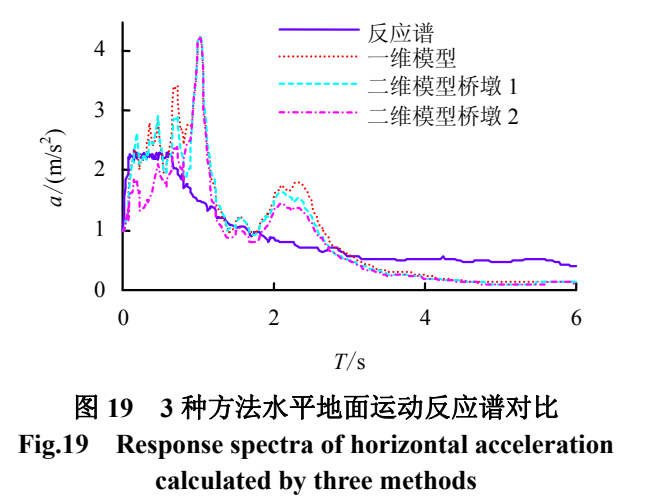
The calculated motions differ in peak amplitude, waveform and frequency content. In the two-dimensional model, the response spectra at the two pier locations also differ substantially. A response spectrum is like a table of test results: place simplified structures with different natural periods under the same earthquake motion and see how strongly each responds.
The curves show that a site redistributes ground-motion energy. Some vibration rhythms are amplified, while others become relatively weaker. Choosing an input by its maximum acceleration alone can therefore overlook features important to long-period bridges.
To read the spectra, first locate the bridge's vibration period on the horizontal axis and compare the curves above it, rather than simply seeking the tallest peak. The paper finds that the predominant period from the two-dimensional site calculation extends beyond the plateau of the code response spectrum. The site's amplification rhythm therefore differs from the typical shape assumed by that spectrum. For a slowly vibrating long-span bridge, this shift in peak position may be more informative than a single acceleration value.
Bring the valley back into bridge design
The study also moves the observation points progressively away from the valley to examine how topographic effects vary with distance. Spatial differences are pronounced near the valley, while responses farther away gradually approach those of horizontally layered ground. River water has a smaller influence on horizontal motion and a more noticeable influence on vertical motion.
For this type of river crossing, understanding the site and understanding the bridge go together. Including the layers beneath the piers and the valley geometry allows the computer model to experience shaking that better represents the actual site conditions.
The water's role also illustrates why direction matters: coupled movement of the water and riverbed affects vertical dynamic response, while horizontal changes are relatively small. The study relates valley depth, layer thickness and distance from the valley to the extent of the affected region. Defining bridge inputs therefore involves two decisions: how large the computational domain must be, and how much spatial variation must be retained along the bridge. Resolving both helps organize the subsequent structural analysis.