During the same earthquake, a slope crest and toe can shake differently. A computer study usually retains only a section of the slope and underlying soil. How its cut edges are treated determines both whether incoming waves are transmitted correctly and whether calculated amplification comes from the slope or from the artificial boundaries.
The bottom and sides encounter different wave fields
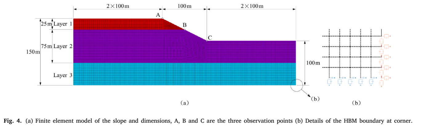
Artificial boundaries replace the ground that extends beyond a numerical model. Ideally, they admit external seismic inputs while absorbing energy travelling outward from within. A slope has different ground elevations on its two sides, and its bottom and lateral boundaries encounter different wave-field conditions.
The paper proposes a hybrid boundary method combining different boundary treatments with equivalent inputs. Three soil layers, the crest and the toe define the study setting. The small diagram on the right shows how boundary devices connect at a model corner.
Springs and dashpots commonly approximate the restraint and energy transfer provided by the surrounding ground. Springs represent restoring action, while dashpots help absorb outgoing energy; loads corresponding to incident waves must also be applied. In a layered slope, the lateral boundaries connect to layers at different elevations, while the bottom has another input condition. The hybrid method organizes these treatments by location so their roles match the actual wave-propagation paths.
Check the model before interpreting the slope
The hybrid boundary is compared with four common treatments and with a larger reference model. Comparisons consider both peak acceleration and the shape of the complete history. A close peak value can still hide waveform errors, so both checks are needed.
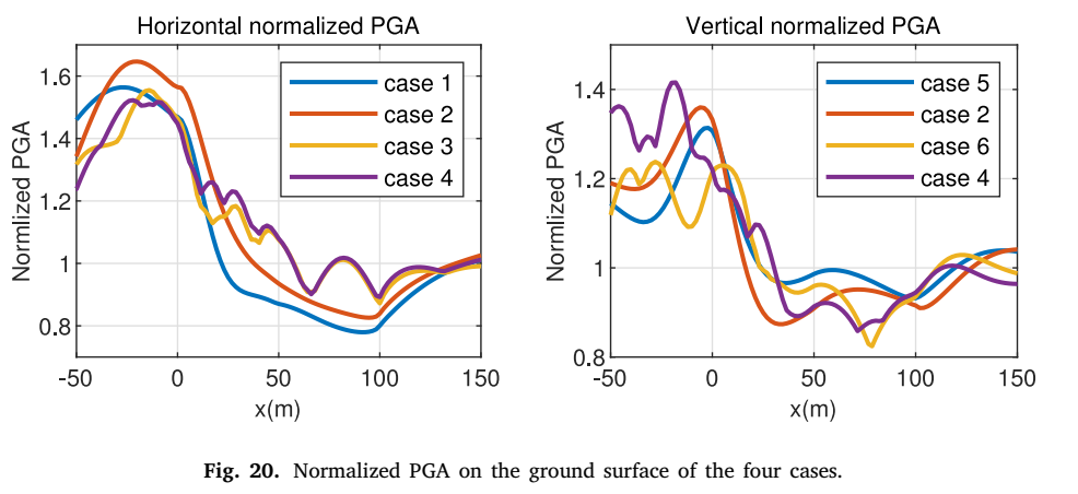
Once the method is validated, the slope's influence becomes clearer. At the site examined, response is amplified near the crest and reduced near the toe. Normalized peaks use the free-field result as their reference; values above 1 indicate that topography increases local peak acceleration.
Curves along the slope make this spatial variation visible: moving along the horizontal axis from the crest side toward the toe, the response changes from local high values. Horizontal and vertical components have their own patterns, so the original figure presents them separately. The paper also uses waveform-similarity measures to check whether peaks and troughs occur in corresponding time intervals. Combining peak and waveform comparisons helps distinguish accurate propagation from a merely coincidental match at one maximum.
Reliable boundaries reveal the effects of terrain
Spatially varying slope response means that nearby roads, buildings and other facilities can receive different dynamic inputs. A curve of peak response along the slope contains more information than one uniform amplification factor.
The hybrid boundary method controls the effects of artificial truncation so that spatial differences mainly reflect the terrain and geology. It provides a more reliable computational connection for site-response analysis in sloping terrain.
The larger reference model is important too. Moving artificial boundaries sufficiently far away reduces their interference with the observation region during the time of interest. These results can then evaluate a smaller model. If the smaller model preserves the main waveforms and spatial patterns, it can investigate slope details with less computation. This compares efficiency and accuracy on the same basis and provides a sound starting point for varying slope geometry, soil properties or seismic inputs.